What Kind of Place Is This, Exactly?
Mpumalanga sits in South Africa's northeast, sharing a border with Mozambique and Eswatini to the east and the Limpopo Province to the north. Geographically, it is a province of two completely different worlds stacked on top of each other. The Highveld plateau — cool, green, and agricultural — occupies the west. The Escarpment then drops sharply, in places almost vertically, through mist-draped forests and plunging waterfalls into the Lowveld: a flat, hot, subtropical wilderness that is one of the most biodiverse habitats on the continent. The altitude drop in places exceeds 1,000 metres in the space of a few kilometres, which means you can go from jacket weather to T-shirt weather in the time it takes to drive a short mountain pass.
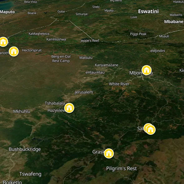
The province's backbone for backpackers is what locals call the Panorama Route — an informal name for the R532 and R534 that string together the escarpment's greatest viewpoints, gorges, waterfalls, and forestry towns between Graskop and Tzaneen. The towns along this route — Graskop, Sabie, Hazyview, White River — are small, unhurried, and built on a combination of forestry, tourism, and the overflow from Kruger. They have the slightly strange, timeless quality of places that exist because of the landscape they're surrounded by, and which don't quite make sense in any other context. You will like them.
To the east, the western boundary fence of Kruger National Park runs for most of the province's length, with multiple access gates within an hour of the escarpment towns. Staying on the Panorama Route gives you safari access without staying inside the park itself — and the hostels that have grown up around the Kruger gates are some of the most characterful places to stay in South Africa. More on this shortly.
The Landscape: An Attempt at Description
Blyde River Canyon is the third largest canyon on earth and the largest green canyon — meaning, unlike the Grand Canyon or Fish River Canyon, it is covered in dense subtropical vegetation rather than bare rock. The statistics don't do it justice: 26 kilometres long, up to 800 metres deep, the Blyde River running through its floor. From the main viewpoint at Bourke's Luck Potholes — cylindrical rock formations carved by river erosion into extraordinary shapes — you look down into a gorge that simply shouldn't exist at this scale. From the Three Rondavels viewpoint higher up, you see the full sweep of it: three enormous domed rock formations rising from the canyon floor, named by early settlers after the round thatched huts of the local communities, their geology entirely different from the surrounding cliff faces. The light on these rocks at sunset turns them the colour of old copper. No photograph you have ever seen of this place is accurate. No photograph can be.
God's Window is the most famous viewpoint on the Panorama Route, and the name is somewhat earned. From a wooden viewing platform on the escarpment edge, you look out over the entire Lowveld — flat, golden, stretching to the horizon — from a height of 1,730 metres. On clear mornings, you can see the Mozambican coast. Below you, the escarpment falls away through mist forest and cliff faces and birdsong. The experience of standing there and trying to comprehend the scale of what you're looking at is one of the genuinely vertiginous moments available to travellers in southern Africa. It costs nothing. It takes twenty minutes to drive to from Graskop. You will not forget it.
The Sabie and Graskop waterfalls — Mac-Mac Falls, Lone Creek Falls, Lisbon Falls, Horseshoe Falls — are each spectacular enough that, in any other context, they would be the headline attraction of an entire region. Here, they are the warm-up act. Hire a car, buy a bottle of water, and take a full day to drive the route.
Understanding the Region: Three Zones, Three Experiences
The Escarpment Towns (Graskop, Sabie, Pilgrim's Rest): This is where most backpackers base themselves, and for good reason. Graskop is the most central to the Panorama Route viewpoints and is the smallest, most characterful of the three. It is famous throughout South Africa for a single thing: the pancake restaurant on its main street. This sounds absurd and is, in fact, a genuine pilgrimage destination. The pancakes — enormous, thick, served sweet or savoury, to queuing tourists on the pavement — are inexplicably, definitively excellent. Sabie is larger and more relaxed, surrounded by pine and eucalyptus plantations and the waterfalls of the Sabie River valley. Pilgrim's Rest is a living museum: a gold-rush town from the 1870s that has been preserved in its entirety as a national monument, with its original Victorian-era buildings still intact on a single main street. It is slightly eerie and entirely wonderful.
The Lowveld Kruger Gateway Towns (Hazyview, White River, Malelane): The towns closest to the Kruger access gates operate at a different pace — hotter, flatter, more oriented around the logistics of getting people into the park. Hazyview sits close to the Numbi and Phabeni gates; White River is slightly further back but has better facilities. These are not places you visit for their own sake; they are staging posts for the bush. The hostels in this zone are calibrated accordingly — they understand that their guests are there to do wildlife, and they either run safaris themselves or have solid relationships with operators who do.
Ermelo and the Highveld: Ermelo is the largest town in the western Highveld of Mpumalanga — agricultural, unremarkable to look at, and genuinely useful as a transit point for travellers coming up from KwaZulu-Natal or through from the Drakensberg. It has one backpacker hostel that serves this transit function well without pretending to be more than it is.
Mpumalanga FAQs For Backpackers
Kruger: The Basics You Need to Know
Kruger National Park is 19,485 square kilometres — roughly the size of Wales. It runs from the Crocodile River in the south to the Limpopo River in the north, a distance of about 350 kilometres. The western boundary fence is what you'll encounter from Mpumalanga, with the main southern gates — Malelane, Crocodile Bridge, Numbi, Paul Kruger (Skukuza) — all accessible from this side of the province.
You do not need a tour to see animals in Kruger. You can self-drive in a standard hire car on the park's tar and gravel roads, paying the daily conservation fee at the gate. The Big Five are genuinely all present and in significant numbers — Kruger has the largest population of wild lions in the world, and elephant sightings are effectively guaranteed. The key is patience and early mornings: the first two hours after gate opening (before 8 AM) and the last two hours before gate closing (after 4 PM) are when animal activity peaks, particularly at the waterholes. A pair of binoculars costs less than a single night in a Cape Town hostel. Buy them before you go in.
Gate opening times vary by season: roughly 5:30 AM in summer, 6 AM in winter. You must be back at the gate or in a SANParks camp by gate closing time, which ranges from 5:30 PM in winter to 6:30 PM in summer. The fines for arriving at a gate after closing are substantial. Set a reminder on your phone and leave the park with more time than you think you need — you will stop for a lion.
Conservation fees for foreign visitors are approximately R480 per adult per day (roughly €23) as of 2025. This is paid at the gate and is valid for the full day. Guided open-vehicle safaris from the Hazyview-area hostels typically run R650–R1,200 per person for a half-day drive and are worth doing at least once — experienced guides find and interpret animals in ways that transform a self-drive into something deeper.
Getting Around: The Hire Car Question
Mpumalanga essentially requires a hire car. Public transport connects the major towns but does not serve the viewpoints, the waterfalls, the canyon viewpoints, or the Kruger gates in any useful way. The Panorama Route is a driving route: you stop the car at a viewpoint, walk to the edge, stand there for a while, get back in the car, drive to the next one. There is no other way to do this properly.
Hire cars are available from Johannesburg's OR Tambo International Airport, which is the standard arrival point for most travellers coming to this region. Mpumalanga Airport (MQP, near Nelspruit/Mbombela) has a smaller selection but is served by Airlink flights from Cape Town, Johannesburg, and Durban. Budget Rent-a-Car, Avis, Europcar, and Hertz all operate from both airports. The drive from OR Tambo to Hazyview takes approximately 3.5 hours on the N4 and then the R40 — manageable on arrival day if you land in the morning. The drive from OR Tambo to Graskop via the R40 and R532 takes about 4.5 hours and is one of the more dramatic arrival experiences in southern Africa: you come across the Highveld, climb the escarpment on a sequence of tight mountain passes, and the Lowveld unrolls below you to the east.
Uber is available in Nelspruit/Mbombela and to a limited degree in Hazyview and White River. It does not function reliably in Graskop, Sabie, or at the Kruger gates. For everything beyond the larger towns, you need your own wheels.
What Does It Cost?
Mpumalanga is substantially cheaper than Cape Town or the Garden Route. A dorm bed in any of the hostels on this list runs R180–R350 per night. A meal at a local restaurant in Graskop or Sabie — a proper sit-down meal, not a sandwich — costs R80–R150. A Kruger day visit costs approximately R480 in conservation fees plus fuel. A guided safari from a Hazyview hostel runs R650–R1,200 per person. The famous Graskop pancake: about R90. The waterfall day drives: free or a small parking fee. The aggregate cost of a week in this part of the world, including safari, is manageable on a backpacker budget in a way that the more famous safari destinations of East Africa are not.
Malaria: The Thing You Have to Know
The Lowveld — including the Kruger National Park, Hazyview, and White River — is a malaria area. This is not a minor caveat. Malaria is a serious illness transmitted by mosquito bites, and the risk in the Lowveld is real, particularly in summer (October–April) when temperatures and mosquito populations are higher. The escarpment towns (Graskop, Sabie) are at higher altitude and generally considered low-risk, but the moment you descend to Hazyview or drive into Kruger, you are in a malaria zone.
What to do: consult a travel health clinic or doctor before you travel and take antimalarial prophylaxis as prescribed. The main options are doxycycline (cheap, widely available, must be taken daily), Malarone (atovaquone-proguanil, more expensive, very effective, fewer side effects), and mefloquine (weekly, but with documented neuropsychiatric side effects in some users — not recommended for most travellers). Use DEET-based insect repellent at dusk and after dark. Wear long sleeves and trousers in the evenings. Sleep under a mosquito net if the hostel provides one; if it doesn't, ask why. Symptoms of malaria — fever, chills, headache, muscle aches — can appear 7 to 30 days after a bite. If you feel unwell in the weeks after leaving the Lowveld, see a doctor immediately and tell them you were in a malaria area. Early treatment is straightforward. Delayed treatment is dangerous. Take this seriously.
The Best of the Panorama Route: A One-Day Itinerary
Base yourself in Graskop or Sabie the night before. Leave before 7 AM. Drive north on the R532 to Bourke's Luck Potholes (40 minutes from Graskop) for opening time — the morning light in the gorge is extraordinary. Spend 45 minutes there, then continue north on the R532 to the Three Rondavels viewpoint in the Blyde River Canyon Nature Reserve. Allow at least an hour — this is the defining viewpoint of the whole route. Drive back south to the R534 turn-off for God's Window and Pinnacle Rock. God's Window in the morning, on a clear day, with the Lowveld spread below you: budget 30 minutes and consider that it may be longer. Continue to Lisbon Falls (20 minutes south on the R37). Stop at Mac-Mac Falls and Pools if you want a swim — the pools below the falls are clean and cold and perfect for a midday break. Return to Graskop for the famous pancake lunch. In the afternoon, drive the R40 down to Hazyview for the sunset over the Lowveld from the lower escarpment, and consider the question of whether to drive into Kruger the following morning. You will decide yes. Everyone decides yes.
Further Reading
Ready to map out the rest of your adventure? For more general info on backpacking South Africa, see our comprehensive home page. We also highly recommend checking out our expert backpacking advice section to make sure you stay safe and save money on the road. If you need help structuring your travel routes, take a look at our suggested itineraries for tours of South Africa. For more info on backpacking, including access to our offline app and interactive PDF guide, head over to our resources page.





 SHARE (opens in a new tab)