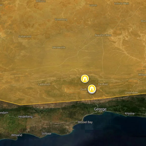
It is important to understand the geography before you go, because "the Karoo" is not one thing. The Great Karoo is the large, open, often desolate northern plateau — the Karoo of imagination, the sheep farms and dorpies and N1 highway stretching to the horizon. The Great Karoo towns of Beaufort West, Graaff-Reinet, Prince Albert, and Nieu-Bethesda each have their own distinct character and reasons to stay. The Little Karoo (Klein Karoo) is a narrow, enclosed valley between the Swartberg Mountains to the north and the Outeniqua and Langeberg ranges to the south — geographically distinct, significantly greener in the valley floor, and dominated in the tourist imagination by Oudtshoorn, the ostriches, the Cango Caves, and the Swartberg Pass. And on the eastern margin, where the Klein Karoo bleeds into the Eastern Cape mountains, lies the extraordinary Baviaanskloof — technically a transitional wilderness zone, but included here because it forms the natural eastern extension of the Karoo backpacker experience and contains, in Go Baviaans, one of the finest outdoor adventure operations in South Africa.
The Karoo does not do much for travellers who need to be entertained. It does not have beaches, nightlife, or a consistently exciting restaurant scene. What it offers, in concentration and at its best, is the experience of being somewhere genuinely quiet, genuinely remote, and genuinely strange — a landscape shaped by forces and timescales that human activity has barely touched. The fossils in the Karoo National Park are the remains of creatures that lived before the dinosaurs. The rock art near Nieu-Bethesda was painted by people who understood this landscape intimately for thousands of years before European contact. The Swartberg Pass was built in seven years from the 1880s by hand-cut dry stone and human labour. The Karoo rewards the traveller who brings curiosity.
Great Karoo vs Little Karoo: What's The Difference?
The distinction matters practically, not just geographically. They are different landscapes, different climates, different distances, and different kinds of trip.
The Great Karoo is enormous — it runs from the Swartberg Mountains in the south to the Roggeveld Escarpment in the north, and from the Hex River Mountains in the west well into the Eastern Cape. The key backpacker towns are Beaufort West (N1 highway, transit point, Karoo National Park), Prince Albert (the most beautiful small town in the Karoo, reached over the Swartberg Pass), and Graaff-Reinet (the fourth oldest town in South Africa, in the Eastern Cape, the gateway to the Valley of Desolation). Nieu-Bethesda, off the R61 north of Graaff-Reinet, is a separate category entirely: a tiny village of artists, eccentrics, and the legacy of the outsider artist Helen Martins, whose Owl House — its rooms encrusted with powdered glass and cement sculptures — is one of the most singular places in South Africa. The Great Karoo's distances are real: these towns are far from each other and far from Cape Town. A car is essential.
The Little Karoo is compact by comparison — a 200km-long valley following the R62, accessible from George and the Garden Route in the south via the Outeniqua Pass, or from Cape Town via Route 62 through the Hex River Valley and the Robertson Wine Route. Oudtshoorn is the main hub: the ostrich capital of the world, the gateway to the Cango Caves, and the starting point for the Swartberg Pass and the extraordinary lost valley of Gamkaskloof (Die Hel). The Little Karoo is relatively easy to reach without a car — Baz Bus serves it on the Garden Route run — and relatively compact to navigate once you are there.
The Baviaanskloof — literally "Valley of the Baboons" — lies east of the Little Karoo, in the Eastern Cape, a 200km-long wilderness valley between the Baviaanskloof and Kouga mountain ranges. It is one of the eight protected areas of the Cape Floral Region World Heritage Site, a place of extraordinary biodiversity and complete remoteness. The only road through it is gravel, mostly. The backpacker operation at Cedar Falls — Go Baviaans — sits on a small island of private land completely surrounded by the wilderness reserve and is the base for the Leopard Trail, one of South Africa's most celebrated multi-day hiking experiences. Getting to the Baviaanskloof requires commitment: it is 4x4 territory for most approaches and mobile signal is non-existent inside the reserve. It is also, by the accounts of everyone who makes the effort, worth every kilometre of dirt road.
Karoo FAQs For Backpackers
Do I need a car?
For the Great Karoo: yes, without reservation. The distances between towns are vast, there is no public transport of any practical use between Karoo dorpies, and the key attractions — the Valley of Desolation, fossil sites, mountain passes, game reserves — are not accessible on foot from any town centre. Beaufort West is the only Great Karoo town served by long-distance bus (Intercape and Greyhound on the N1 Cape Town–Johannesburg route), which makes it a transit point rather than a base. If you are arriving by bus and intend to explore further, you need to rent a car in Beaufort West or arrange transport from your hostel.
For the Little Karoo: more manageable without a car, but still significantly limited. Baz Bus serves Oudtshoorn as a stop on the Garden Route run (George is the nearest Baz Bus hub, from which local taxis and arranged shuttles cover the 70km to Oudtshoorn). The Cango Caves can be reached from Oudtshoorn by arranged shuttle. The Swartberg Pass and Gamkaskloof cannot. For a car-free backpacker, the Little Karoo works as a one-to-two-night Oudtshoorn stop with organised activities, but does not work for independent exploration of the broader region.
For the Baviaanskloof: a 4x4 or high-clearance vehicle is required, and this is non-negotiable. The road through the kloof — particularly the section approaching Cedar Falls from Willowmore — is a serious gravel mountain road. Standard sedans can and do get stuck and damaged here. Go Baviaans can advise on current road conditions when you book; conditions change seasonally and after heavy rain.
When is the best time to visit?
The Karoo is a year-round destination but with significant seasonal differences that affect the experience substantially.
Spring (August–October) is the finest time for the Great Karoo — the Namaqualand wildflower season bleeds into the northern Karoo, the temperatures are ideal for hiking, and the landscape has a freshness after winter rains that the summer bake removes entirely. September and October are the peak months for wildflowers in the Nieuwoudtville and Calvinia areas at the Karoo's northwestern edge.
Summer (November–March) in the Great Karoo means serious heat — 40°C+ days in the valleys, 45°C+ in some Great Karoo towns. The Little Karoo is slightly moderated by the surrounding mountains but still gets brutal. Outdoor activity should be done very early or in the late afternoon. The upside: dramatic thunderstorms roll across the Great Karoo on summer afternoons and the lightning shows are extraordinary.
Autumn (March–May) is the quiet sweet spot — heat dropping, crowds gone, harvest fruit on the farm stalls along the R62, and an amber quality to the light on the Swartberg that photographers pursue specifically. For the Baviaanskloof, March and April are among the best hiking months.
Winter (June–August) can be cold — genuinely cold, below freezing overnight in Prince Albert and the high Swartberg — but the skies are completely clear and the stargazing is at its absolute peak. Snow on the Swartberg Pass makes it temporarily impassable but creates one of the more spectacular sights in the Western Cape. The Great Karoo in winter sunshine — cold, bright, completely silent — has a quality that no other season replicates.
What is Route 62?
Route 62 is the R62 regional road that runs from Worcester in the Western Cape through the Hex River Valley, the Robertson Wine Route, Montagu, Barrydale, Calitzdorp, and Oudtshoorn, continuing into the Eastern Cape through De Rust and Uniondale. It has been marketed as an alternative to the Garden Route N2 and is, by some metrics, the world's longest wine route — covering over 300km through the wine-producing valleys and the ostrich farms and dried fruit co-operatives of the Little Karoo. The route's attraction for backpackers is the variety of what it covers: from boutique wine estates in the Robertson Valley through the quirky character of towns like Barrydale (population 4,000, one excellent coffee shop, one famous roadside attraction, more personality per square metre than most of South Africa) to Calitzdorp — South Africa's undisputed Port wine capital — and finally into the Klein Karoo proper at Oudtshoorn. The full Route 62 from Worcester to Oudtshoorn makes a genuinely satisfying one-day drive with regular stops, or a more leisurely two-day itinerary with an overnight in Barrydale or Calitzdorp.
What is the Swartberg Pass and should I drive it?
The Swartberg Pass is a 27km gravel mountain road connecting Oudtshoorn in the Little Karoo with Prince Albert in the Great Karoo, rising to 1,583 metres through a series of steep hairpin bends built from dry-stone walling and dynamite by Thomas Bain between 1881 and 1888. It is a National Monument, unchanged in alignment from the original construction, and it is one of the most dramatic mountain roads in South Africa — possibly in the world. The views from the summit looking north across the Great Karoo and south across the Klein Karoo valley are vast and disorienting in the best possible way. The road surface is maintained gravel and is passable in a standard sedan in dry conditions, but the drop-offs are real and the bends are sharp. Take it slowly (30–40km/h on the steeper sections), let faster vehicles pass, and do not attempt it in rain or snow. Winter snowfall closes the pass intermittently from June to August. Check conditions before you set off.
The answer to "should I drive it" is yes, unambiguously, if you have a car. The Swartberg Pass is one of the great drives in South Africa and the combination of the pass and Prince Albert — a two-to-three-hour excursion from Oudtshoorn — is one of the most rewarding half-days available to a backpacker anywhere in the country.
What is Die Hel (Gamkaskloof)?
Die Hel — officially Gamkaskloof — is a remote valley in the Swartberg range, enclosed by mountains on all four sides, accessible only by a single 52km mountain track from the top of the Swartberg Pass. It was inhabited by a small community of Afrikaner farming families from the early 19th century until 1991, effectively cut off from the outside world by the mountains that surround it, and the isolation produced a community with its own distinct dialect, customs, and gene pool. The road into Die Hel — a 4x4 track of extraordinary difficulty and beauty — has been the subject of more adventure travel writing than almost any comparable route in South Africa. Cape Nature manages the valley now, and there is camping and self-catering accommodation. The return trip from the Swartberg Pass is approximately 5–6 hours with the drive and a brief visit, or a full overnight with a 4x4. Do not attempt Die Hel without checking road conditions with CapeNature first. The track is genuinely impassable in wet conditions and a breakdown in the valley is a serious situation.
Is the Karoo safe?
The Karoo is, by South African standards, extremely safe. The towns covered on this page — Nieu-Bethesda, Prince Albert, Graaff-Reinet, Oudtshoorn — all have low tourist crime rates. Nieu-Bethesda has essentially no crime against visitors whatsoever; it is a village of a few hundred people where the community knows every face. Prince Albert is similarly small and safe. Graaff-Reinet requires the standard urban awareness in the township areas but is low-risk in the tourist and historic centre. Oudtshoorn is the largest town and warrants the standard small-town South African awareness: phone in pocket, Uber after dark rather than walking unfamiliar streets, valuables in the hostel safe.
The safety risks specific to the Karoo are environmental: heat and dehydration on hikes, remote road breakdown (carry water, a spare tyre, and a basic tool kit on any gravel road journey), and flash flooding in mountain passes and river crossings after heavy rain. The Baviaanskloof flood risk is real and should not be underestimated — the valley narrows in places to sheer gorge walls through which floodwater can travel with catastrophic speed. Stay off valley floors when rain is threatening and read the Go Baviaans flood guidance before hiking.
Further Reading
Ready to map out the rest of your adventure? For more general info on backpacking South Africa, see our comprehensive home page. We also highly recommend checking out our expert backpacking advice section to make sure you stay safe and save money on the road. If you need help structuring your travel routes, take a look at our suggested itineraries for tours of South Africa. For more info on backpacking, including access to our offline app and interactive PDF guide, head over to our resources page.



 SHARE (opens in a new tab)