The Lay of the Land
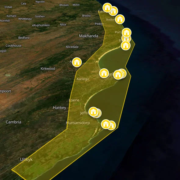
The Sunshine Coast is not a single landscape — it is a sequence of very different ones, all compressed into a coastal strip that takes about five hours to drive end-to-end without stopping, which is not the right way to do it. Coming from the west on the N2 highway, the transition from the Garden Route happens somewhere around Storms River and the Bloukrans Bridge. The Tsitsikamma National Park — still technically Garden Route country — gives way to the lower-key, quieter scenery of the Eastern Cape coast as you pass through Humansdorp and approach Jeffreys Bay. From J-Bay it's a relatively short drive to Gqeberha (Port Elizabeth), the largest city on this stretch and the main transport hub. East of Gqeberha, the R72 coastal road branches off the N2 and runs along the coast itself — slower, quieter, and considerably more beautiful — through a sequence of small towns and river mouths: Blue Horizon Bay, Cannon Rocks, Kenton-on-Sea, Port Alfred, Hamburg, and Kidds Beach before rejoining the N2 for the run into East London.
The countryside behind the coast is pineapple and chicory country — the Eastern Cape's agricultural heartland, with the small towns of Bathurst and Alexandria serving the farms. It is green, undulating, and thoroughly pleasant, and it contains the oldest pub in South Africa (the Pig and Whistle Inn at Bathurst, licensed in 1831 and still serving). The Grahamstown/Makhanda academic city lies inland, home to Rhodes University and the annual National Arts Festival — one of the largest arts festivals in Africa, running for ten days every July and drawing performers and audiences from across the continent and the world.
The Indian Ocean along this coast is warmer than the Atlantic at Cape Town and considerably more swimmable. The Agulhas Current runs south-west along this coastline, keeping sea temperatures in the 18–24°C range year-round — cool enough to be refreshing, warm enough to stay in for an hour. The waves are generally gentler than the Atlantic Seaboard and the bays calmer, which makes the coast genuinely family-friendly in the beach towns. But the Sunshine Coast also has its serious surf spots — Jeffreys Bay most famously, and Nahoon Reef in East London — and the warmer water brings dolphins into the bays year-round, whales seasonally, and the occasional great white to remind you that the ocean here is a living ecosystem.
A Brief History of the Eastern Cape
The Eastern Cape has a history as complicated and as layered as anywhere in South Africa. The region was home to Khoikhoi and San people for millennia before the southward expansion of Xhosa-speaking Nguni communities in the 17th and 18th centuries brought a new dominant culture to the land between the Sundays River and the Kei River. The Xhosa people — a cattle-herding, ancestor-honouring, deeply communal society organised around clan and chieftainship — occupied this landscape for over a century before encountering the expanding frontier of European settlement pushing eastward from the Cape Colony.
What followed was a century of frontier wars — nine of them, running from 1779 to 1879 — between the expanding Cape Colony (British from 1806 onwards) and successive Xhosa confederacies defending their land. They are known as the Cape Frontier Wars, or simply the Xhosa Wars, and they are among the longest sustained colonial conflicts in African history. The British won the last of them. The Xhosa lost everything: their land, their cattle, their political autonomy. The Eastern Cape became, in the aftermath of conquest and the subsequent deliberate impoverishment of the region, one of the poorest provinces in South Africa — a condition it has never fully escaped, and one that shapes the landscape and the people you meet here today.
The Eastern Cape also produced Nelson Mandela, Walter Sisulu, Oliver Tambo, Govan Mbeki, Chris Hani, Steve Biko, and a disproportionate share of the leadership of the African National Congress. Mandela was born at Mvezo in the Transkei, went to school at Qunu, and was initiated as a Xhosa man on the banks of the Mbashe River before going on to save the country. The Eastern Cape is where South Africa's liberation story has its deepest roots, and understanding a little of that history makes everything you see here more legible.
The coastline itself was explored by Portuguese navigators in the late 15th century — Bartolomeu Dias rounded the Cape of Good Hope in 1488 and named various points of the Eastern Cape coastline on his way along the coast — and was later a busy stretch of the shipping route between Europe and Asia. Several significant wrecks lie off this coast, and the diving at certain points along the Sunshine Coast reflects that history. The 1820 Settlers — a group of about 4,000 British immigrants brought to the Eastern Cape to create a buffer between the Cape Colony and the Xhosa frontier — established the towns of Grahamstown, Port Alfred, and several others that still carry their character: small, English in flavour, slightly out of time in the best possible way.
Sunshine Coast FAQs For Backpackers
When is the best time to go?
The honest answer is: almost any time. The Sunshine Coast's 320 days of annual sunshine makes it one of the most reliably pleasant stretches of coastline in South Africa across the full calendar year. But there are nuances worth knowing.
Summer (November–March) brings long, hot days, school holiday crowds in the beach towns, and warm water — sea temperatures peak at 22–24°C in February. It is also the wetter season, with short afternoon rain showers common, though these are rarely day-long events. The crowds in the beach towns (particularly J-Bay and Port Alfred) are primarily domestic South African holidaymakers during the December–January school holidays. Accommodation gets booked out and prices rise; if you're visiting then, book ahead.
Winter (May–August) is surf season on the Sunshine Coast — particularly for J-Bay, where the consistent south-west swells from the Southern Ocean produce the world-class conditions that the point break is famous for. The WSL (World Surf League) Championship Tour event at Jeffreys Bay runs in July, when the surf is at its most powerful. Winter days are warm and dry (average 20–22°C), nights are cool but not cold, and the beaches are largely empty. This is when the Sunshine Coast is at its most relaxed and most beautiful.
The shoulder months (April–May and September–October) offer an excellent balance: good surf, lower crowds, comfortable temperatures, and the Eastern Cape's characteristic golden light in the late afternoon. September and October bring wildflowers to the coastal fynbos and the return of the southern right and humpback whales to the coast between July and December.
Do I need a car?
Yes, for anything beyond a single-town stay. The Baz Bus travels the N2 highway through this region — stopping at Jeffreys Bay and connecting onwards to Gqeberha and East London — which means you can hop between those specific points without a car. But the great pleasure of the Sunshine Coast is the R72 coastal road between Gqeberha and East London, which the Baz Bus does not cover; and the inland day trips (Addo Elephant Park, Bathurst, game reserves around Kenton-on-Sea) require your own vehicle. If you are spending more than two nights in any one location and want to explore the coast and hinterland, hire a car.
What does it cost?
The Sunshine Coast is one of the most affordable stretches of the South African backpacker trail. Dorm beds at the backpacker hostels run from €8–€16 per night — at the lower end for smaller-town hostels in Port Alfred and East London, higher end for well-facilities J-Bay spots. Activities are reasonably priced: a surfing lesson in J-Bay runs approximately €20–€30; a self-drive day at Addo Elephant Park is approximately €15 per person including entry; a kayaking trip on the Kariega River from Kenton-on-Sea costs approximately €20–€30; a snorkelling trip costs approximately €25–€35. Food and drink are very affordable — a meal in a beach restaurant runs €7–€12 for a main course. A comfortable daily budget of €40–€60 covers accommodation, food, one activity, and local transport.
Is it safe?
The beach towns of the Sunshine Coast — J-Bay, St Francis Bay, Port Alfred, Kenton-on-Sea — are among the safer tourist environments in South Africa. They are small, spread out, and operate at a pace that makes the vigilance required in Cape Town or Johannesburg feel rather unnecessary. The standard precautions apply: don't leave valuables in a hire car, use common sense in unfamiliar areas after dark, and heed local advice. Gqeberha (Port Elizabeth) and East London are larger cities with higher urban crime rates — the same urban safety protocols that apply in Cape Town (Uber after dark, phone out of sight, stay in known areas) are appropriate here. The beach areas of both cities are generally fine during daylight hours.
A specific note on the ocean: the Sunshine Coast has a resident great white shark population, and shark incidents — including serious ones — have occurred at Nahoon Reef in East London and at other spots along this coast. Heed any flags or warning systems at beaches you don't know, ask locals about conditions before entering unfamiliar water, and exercise judgement about entering the ocean at dusk or dawn, when sharks are more active. This is not a reason to stay out of the water — millions of people swim and surf this coast without incident every year — but it is a reason to pay attention.
Further Reading
Ready to map out the rest of your adventure? For more general info on backpacking South Africa, see our comprehensive home page. We also highly recommend checking out our expert backpacking advice section to make sure you stay safe and save money on the road. If you need help structuring your travel routes, take a look at our suggested itineraries for tours of South Africa. For more info on backpacking, including access to our offline app and interactive PDF guide, head over to our resources page.











 SHARE (opens in a new tab)