For backpackers, the Cederberg is specifically a hiking and rock-climbing destination. It is not a party region, not a beach region, and emphatically not a digital detox-by-accident situation — phone signal is genuinely absent for most of the interior, and the rhythm of the place actively discourages screens. What it offers instead is a quality of silence, light, and landscape that is difficult to find anywhere in the country within this distance of a major city. Stars here — with no light pollution and the Southern Cross directly overhead — are so dense that the Milky Way casts a shadow. At dawn, the sandstone peaks turn from charcoal to amber to gold in a sequence that takes about four minutes and leaves you understanding, without any further explanation, why the San considered this landscape sacred.
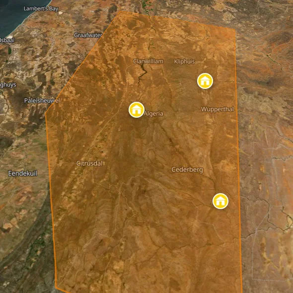
The Cederberg Wilderness Area — the core protected zone administered by CapeNature — covers roughly 71,000 hectares. Around it lies the broader Cederberg Conservancy, a patchwork of private farms that have agreed to conservation principles, running to a further 160,000 hectares. Access is through Clanwilliam in the north (from the N7, about 2.5 hours from Cape Town) or through Citrusdal in the west (slightly further south on the same N7). The central Algeria area, about 30km from either town on gravel roads, is where the majority of hikers base themselves. It is worth knowing before you go: petrol stations do not exist in the Cederberg interior. Fill your tank in Clanwilliam or Citrusdal.
The wildlife is less immediately dramatic than a game park — the Cederberg has no Big Five, no guided safari vehicles, no ranger briefings. What it has instead is the Cape leopard (small, reclusive, and almost certainly watching you from the rocks without you ever knowing it), baboon troops that move through camp in the mornings, Cape clawless otters in the rivers, an extraordinary variety of fynbos birds including the protea canary and the Victorin's warbler, and the ancient silence of rock formations that were shaped by water 500 million years ago. The endemic Clanwilliam yellowfish, found in the Olifants River tributaries, makes the streams here significant even to people who don't hike.
The backpacker infrastructure in the Cederberg is deliberately minimal and spread out across the landscape. You are not going to find a strip of hostels and a bar scene. You are going to find three places — Cederberg Oasis deep in the conservancy, Gecko Creek on the southern edge near Citrusdal, and Heuningvlei on the remote eastern side — each of which has a completely distinct character and draws a completely distinct type of traveller. This page covers all three.
Cederberg FAQs For Backpackers
Do I need a permit to hike in the Cederberg?
Yes — and this is not optional or theoretical. CapeNature manages the Cederberg Wilderness Area and requires a permit for all overnight hiking in the formal wilderness zone. Day hikes on CapeNature-managed trails also require a permit. You can book permits online through the CapeNature website or at the Algeria Huts office if you arrive in person and there is availability. The permits limit the number of hikers in the wilderness at any one time — this is a genuine conservation measure, not bureaucratic box-ticking, and it is effective. In peak season (school holidays, Easter, September-October) the Algeria permits can sell out weeks in advance. Book before you leave Cape Town.
Importantly: permits are required for the CapeNature wilderness area specifically. If you are hiking on private farm conservancy land — which includes much of the territory around Cederberg Oasis and Gecko Creek — different rules apply. Your host will tell you exactly what is required and will often sort the logistics for you. The Wupperthal area around Heuningvlei is Moravian Church communal land and requires separate permission through the community. Again: ask your hosts. They know this area comprehensively and navigating permits is part of what they do.
When is the best time to visit?
Spring (August–October) is the classic answer — the fynbos is in flower, the days are warming up but not yet brutal, the rivers are running well from winter rains, and the light on the sandstone is extraordinary. September and October in particular are widely regarded as the peak months, and Algeria permits reflect this with higher demand.
Summer (November–February) is viable but demanding. Temperatures in the Cederberg interior routinely exceed 40°C in January. Heat haze sits over the rock formations by mid-morning. Hiking is best done very early — out by 6:00 AM, off the mountain by 11:00 AM — and the afternoons are for swimming in rock pools and sitting in the shade of a lapa. Some trails are closed during fire season. That said, summer evenings are magnificent, the stargazing is at its best, and the swimming holes in the Olifants River tributaries are at their most inviting.
Autumn (March–May) is underrated. The summer crowds have gone, the days are cooler and more comfortable, and the landscape has the dry, amber quality of a Cederberg that has been baked all summer and is now settling into itself. It is arguably the best time of all for rock climbing.
Winter (June–July) is cold — genuinely cold at altitude, with overnight temperatures dropping below freezing on the high peaks and occasional snowfall on the upper Cederberg. Not unpleasant if you are well-equipped, and spectacularly beautiful when the peaks carry snow. But this is serious mountain weather and requires proper gear. The Olifants River runs fast and full, the swimming holes are bracingly cold, and you will have the place almost entirely to yourself.
Do I need a 4x4?
It depends on where you're going and when. The main Algeria valley road from Clanwilliam — the Algeria Road — is a graded gravel road that is generally passable in an ordinary sedan in dry conditions, though it takes about 45 minutes on dirt. Gecko Creek's access road is described in reviews as corrugated and rocky — a high-clearance vehicle is recommended, and after rain it can get difficult. Cederberg Oasis is deeper in the conservancy on gravel roads and the condition varies seasonally. Heuningvlei is the most remote of the three: roughly 15km from Wupperthal on a mountain road that was severely damaged by floods in 2023–2024 and has required 4x4 conditions for much of that period. Before travelling to Heuningvlei, call ahead and ask about current road conditions. This is not a precaution — it is essential. The GroundUp news service reported in October 2024 that sections of the Heuningvlei road remained severely damaged following consecutive years of flooding. The situation changes with rainfall and repair work. Do not assume it is passable because it was passable last season.
What is the Wupperthal Mission and why does it matter?
Wupperthal is a Moravian Mission town established in 1830 in a remote mountain valley on the eastern side of the Cederberg. It is one of a string of fourteen outpost villages — the buiteposte — strung along the eastern boundary of the wilderness, communities that have existed in relative isolation for nearly two centuries, their residents farming subsistence crops, producing dried fruit, and cultivating Rooibos tea using traditional methods. The community at Heuningvlei — one of those fourteen outposts — converted the old primary school into a backpackers lodge as part of a community development initiative, and the tourism economy it generates is direct income for the families who live there.
Visiting Heuningvlei is not simply a hiking trip. It is, unavoidably, an encounter with a community whose relationship to this landscape goes back generations, whose cultural identity was shaped by the Moravian mission tradition (the old church, with its characteristic white gabled architecture, is still the centre of community life), and whose economic vulnerability — dramatically illustrated by the tourism collapse caused by flood-damaged roads since 2023 — is a direct consequence of infrastructure neglect in poor rural communities. The donkey cart trail, which provided the main income for many families, was closed for extended periods when the roads that supported it were washed away. Coming here and spending money matters in a way that spending money in a city hostel does not.
Is there mobile signal or Wi-Fi in the Cederberg?
In the interior — no. Or very little, and unreliably. The Algeria valley has almost no signal on any network. Gecko Creek reports receiving most cell networks in the camp area, but Wi-Fi is limited to device charging rather than data streaming. Cederberg Oasis has Wi-Fi at the main facility. Heuningvlei has no reliable signal and this should be considered a feature rather than a drawback. Download your maps (Maps.me or Google Maps offline), your reading material, and whatever music you want before you leave Clanwilliam. The absence of signal is part of what makes the Cederberg feel like the Cederberg.
The rock art: how do I find it and what are the rules?
The Cederberg contains one of the largest concentrations of San Bushman rock art in the world, with hundreds of sites containing paintings ranging from a few hundred to over 6,000 years old. The paintings depict animals, human figures, and abstract geometric forms associated with shamanic trance states — they are not decorative art but a record of spiritual experience, and their significance to the descendants of the San people who made them is profound and ongoing.
Some sites are well-known and accessible without a guide — the Stadsaal Caves in the Algeria area are signposted and visited by many hikers independently. Others are known only to local guides. The rules are non-negotiable: do not touch the paintings under any circumstances. The oils from human hands accelerate deterioration of pigments that have survived thousands of years of African weather. Do not apply chalk or anything else to make them more visible for photographs. Do not light fires near painted rock surfaces. Treat each site as what it is: an irreplaceable cultural record that you are privileged to be looking at.
The best rock art guide experiences in the region are offered through the Heuningvlei community, where local guides lead visitors to sites that are not accessible independently and provide context that no guidebook can replicate. Cederberg Oasis's owner Gerrit also hand-draws hiking maps that include rock art sites and is a knowledgeable source on what can be reached independently. Ask your hosts — the accessible sites differ significantly from the sensitive ones, and local guidance on this matters.
Safety In The Cederberg
The Cederberg's safety concerns are almost entirely environmental rather than criminal. This is one of the regions of South Africa where you simply do not need to worry about the urban safety issues that occupy so much mental space elsewhere in the country. The risks here are the risks of a mountain wilderness: heat, cold, dehydration, flash flooding, and getting lost on unmarked trails.
Heat And Dehydration
The Cederberg's semi-desert climate means summer temperatures that routinely exceed 40°C in the valleys, with rock surfaces heating to temperatures that can burn skin on contact. The cardinal rule is simple: carry at least 2 litres of water per person for any hike, more in summer. Start early — ideally on the trail before 7:00 AM in summer — and be off exposed ridgelines by mid-morning. The rivers and rock pools are clean (no bilharzia, no crocodiles), which means that on most trails there are opportunities to refill water if you have a filter or purification tablets. But don't rely on this for planning purposes. Carry what you need. Heat exhaustion in the Cederberg interior, far from road access, is a serious and avoidable risk.
Getting Lost
Trail marking in the Cederberg ranges from good to non-existent depending on where you are. The main CapeNature trails are reasonably well-marked, but paths on private conservancy land and the network of tracks around the Wupperthal outpost villages often require local knowledge. Download an offline topographic map before you leave. Tell your hostel exactly where you are going and what time you expect to return. If you are doing multi-day routes alone, register with CapeNature at the Algeria office. The wilderness here is real, and search-and-rescue operations are expensive, slow, and conducted by people who have better things to do.
Flash Flooding
The Cederberg's sandstone gorges and river valleys can flood with extraordinary speed when rain falls on the upper mountain catchments, even when skies in the valley appear clear. Do not camp in dry riverbeds or kloofs. If the sky over the high peaks darkens, move to higher ground. The catastrophic flooding that destroyed roads around Heuningvlei in 2023 and 2024 is a reminder that Western Cape mountain weather is not gentle. Check the forecast before entering the interior and have a plan for shelter if conditions change.
Crime: A Realistic Assessment
The Cederberg interior has an extremely low crime rate against visitors. This is genuine wilderness farming country — the communities are small, connected, and not part of the criminal economy that affects urban South Africa. Leave valuables locked in your vehicle or in the hostel safe, exercise the basic precautions you would anywhere, and otherwise relax. The hostels covered on this page are all community-embedded or family-run operations where your presence and your security are taken personally. This is not Cape Town. Act accordingly.
Further Reading
Ready to map out the rest of your adventure? For more general info on backpacking South Africa, see our comprehensive home page. We also highly recommend checking out our expert backpacking advice section to make sure you stay safe and save money on the road. If you need help structuring your travel routes, take a look at our suggested itineraries for tours of South Africa. For more info on backpacking, including access to our offline app and interactive PDF guide, head over to our resources page.