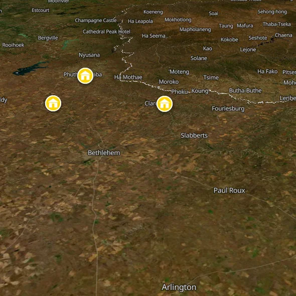
The eastern corner of the province is a different country. Here the Free State highveld runs headlong into the Maluti Mountains and the foothills of the Drakensberg, and the landscape transforms in a way that is almost hallucinatory in its abruptness. The flat grasslands end. Sandstone cliffs appear, glowing gold and amber in the late afternoon sun. The air gets colder and cleaner. And in a valley ringed by those cliffs, three hours from Johannesburg, you find Clarens -- a small town of sandstone buildings, art galleries, craft breweries and excellent restaurants that operates on a schedule that makes almost no logical sense: abandoned and peaceful on weekdays, thronging with day-trippers and weekend visitors from Joburg on Saturdays, then silent again by Sunday evening. Twenty kilometres down the road from Clarens is Golden Gate Highlands National Park, where the sandstone formations reach their most spectacular and the hiking trails are some of the finest and most varied in South Africa.
These two places, Clarens and Golden Gate, are the reasons to come to the Free State. Everything else in this province is for the passing through.
About Clarens
Clarens was founded in 1912 and named after the Swiss town of Clarens-Montreux, where exiled South African President Paul Kruger spent the last years of his life. It is one of those facts that seems too neat to be true and is true anyway. The original town was a small farming community at the foot of the Rooiberge mountains, built from the local sandstone that gives every building its warm amber colour. For most of the 20th century it was a stopping point on the road to nowhere in particular, a place where farmers from the Eastern Free State came to do their banking and their shopping.
Something happened to Clarens in the 1990s. Artists began arriving -- drawn by the light, the mountains, the cheap property, the silence. Galleries opened. Guesthouses followed. Restaurants appeared that served food which had no business being this good in a town this small and this remote. By the early 2000s Clarens had become a functioning art village, with more galleries per square metre than most South African cities, a craft brewery that locals talk about the way Capetonians talk about the best spots on Long Street, and a weekend tourist trade from Johannesburg that has the town's population doubling on a Saturday morning and returning to near-zero by Monday.
This is the rhythm of Clarens, and understanding it changes how you plan your visit. On a Tuesday in winter, you can walk the entire length of President Square and the town's main streets and encounter almost nobody. The galleries are open but unhurried. The restaurants have tables available. The mountains are there and the air is cold and clear and the town has a quality of stillness that makes it feel like you have discovered a film set that has been left running between productions. On a Saturday in summer, the same streets are packed with Joburg weekenders -- couples with expensive SUVs, mountain bikers, trail runners, people who have driven three hours specifically for lunch at Clementines and a tasting flight at the Clarens Brewery. Both versions of Clarens are real and both are enjoyable. The midweek version is just considerably more yours.
The town itself is small enough to walk entirely in 20 minutes. President Square -- the central market square -- is flanked on all sides by cafes, galleries and shops. The architecture is largely sandstone, built from material quarried in the surrounding mountains, and it gives the whole town a visual consistency and warmth that is unusual in South Africa. The Rooiberge mountains ring the eastern and southern edges of the village, close enough that you can be on a trail within 10 minutes of leaving the square. The Clarens Village Conservancy -- a protected area of mountain terrain immediately adjoining the town -- is accessible on foot and free of charge. The Ash River flows around the northern edge of town and provides the rafting and fishing that draws a different kind of visitor.
A word on Clarens and race: the town is almost entirely white in its business ownership, tourist population, and residential character. This is a product of South Africa's history and the economics of Eastern Free State property. The workers in the kitchens, the cleaners in the guesthouses, the casual staff in the galleries are almost entirely Black and coloured South Africans from the surrounding townships of Kgubetswana and Assegaai. This is not unique to Clarens -- it is the pattern across most of the country's tourist towns -- but it is worth naming rather than ignoring. The inequality is present. The tip you leave at the Clarens Brewery means more, in proportion to what the person serving you earns, than the tip you left at a Cape Town restaurant. Tip generously and directly.
About Golden Gate Highlands National Park
Golden Gate Highlands National Park is South Africa's most visually spectacular national park that nobody outside the country has heard of. Kruger gets the international press. Golden Gate gets the local secret-keepers, the serious hikers, and anyone who drove past it once with the windows down and immediately pulled over to stare.
The park covers approximately 340 square kilometres of Maluti Mountain foothills in the northeastern corner of the Free State, on the border with Lesotho. It was established in 1963 around the most remarkable natural feature of the area: the Brandwag Rock, a 20-storey sandstone cliff that glows, depending on the light and the time of day, in colours ranging from deep ochre to pale yellow to a hot, electric gold. This is where the park gets its name. When the late afternoon sun hits the Brandwag at the correct angle, usually in the hour before sunset, the entire cliff face appears to be lit from within. It is one of those natural phenomena where photographs are technically accurate and somehow completely inadequate.
The park's wildlife is not the point. Let that be clear from the outset, because anyone arriving expecting a Kruger-style Big Five experience will be confused. Golden Gate has black wildebeest -- one of the largest herds in South Africa, streaming across the highland plateau in groups of 50 to 100 -- along with eland, blesbok, Burchell's zebra, springbok, and a population of the rare oribi antelope. There are no lion, no elephant, no leopard, no buffalo, no rhino. The wildlife is spectacular in its own way -- a landscape-scale experience of open African grassland with game moving across it -- but this park is primarily about the rock, the sky, the hiking, and the extraordinary quality of the light at dawn and dusk.
The Brandwag Rest Camp and Glen Reenen Rest Camp are the park's accommodation hubs. Glen Reenen is the more accessible, sitting at around 1,900 metres above sea level beside the Little Caledon River, with a shop, restaurant, petrol station and information centre. The Highlands Mountain Retreat sits higher, at 2,230 metres, with eight log cabins tucked into the mountainside and views across the valley that make it one of the more atmospheric places to sleep in South Africa. None of these is cheap by backpacker standards; Clarens Inn, 20km away in Clarens, is the obvious budget base for Golden Gate day trips.
A practical note on park fees and entry: unlike most South African national parks, Golden Gate has no entrance gate and no entrance fee for driving through. The public R712 road runs straight through the park from Clarens to Phuthaditjhaba and is a public road. You are charged only if you stop to hike, use the rest camps, or visit specific facilities. Day visitor fees (as of early 2026) run approximately R252 per person for international visitors (around €12.50), payable at the Glen Reenen information centre. SANParks Wild Card holders enter free. If you have a Wild Card and are doing South Africa properly, you already know this and it is paying for itself.
Free State FAQs For Backpackers
When is the best time to go?
The Eastern Free State is a year-round destination, but the different seasons deliver very different experiences.
Summer (October to February) is warm to hot by day (25-32 degrees C at peak), with spectacular afternoon thunderstorms that build rapidly over the Maluti Mountains and generally clear by evening. The landscape is intensely green, the wildflowers in Golden Gate are at their best from September onwards, and the trails are warm enough to hike in a t-shirt by 9am. The downside is that the thunderstorms make afternoon hiking unpredictable, and Clarens in summer -- particularly over Christmas and New Year -- is packed with Joburg visitors. Accommodation books out weeks in advance for Christmas and long weekends.
Autumn (March to May) is the genuine sweet spot. The Maluti Mountains turn gold and amber, reflecting the sandstone cliffs in a way that feels like the landscape has been designed by someone who understood colour. The summer crowds have largely dispersed. The temperature is mild (15-22 degrees C by day, cold at night). The afternoon thunderstorms become less frequent. This is when Clarens is at its most beautiful and most comfortable, and when the Clarens Craft Beer Festival typically takes place (usually the last weekend of February, sometimes bleeding into early March -- check dates).
Winter (June to August) brings cold -- properly cold, by South African standards. Night temperatures regularly drop below freezing, and snowfall on the Maluti peaks is not unusual. Golden Gate is especially dramatic in winter: clear blue skies, the sandstone cliffs in sharp contrast, thin air, and trails that are quiet and uncrowded. Pack serious layers. The Clarens fireplaces come into their own. Several of the cafes and restaurants on President Square are designed specifically around their wood-burning stoves, and a winter Saturday in Clarens -- cold air, hot coffee, a fire, mountains visible from every window -- has a quality that the summer bustle cannot match.
Spring (September) is when the wildflowers explode across the Free State and the Golden Gate grasslands come alive with colour. Bird activity peaks. The temperature rises back to comfortable hiking range. Spring is arguably the best single season for Golden Gate specifically.
Do I need a car?
Clarens is accessible on public transport, with difficulty. Minibus taxis run from Bethlehem (about 40km to the north), and Bethlehem is accessible from Johannesburg and Bloemfontein on the Translux and other intercity bus services. From Bethlehem to Clarens, local taxis make the run irregularly -- ask at the Bethlehem taxi rank, be patient, and have a backup plan. The Baz Bus does not service this route.
Once in Clarens, the town itself is entirely walkable. The Clarens Village Conservancy trails start from the edge of town on foot. The brewery, the galleries, the restaurants, and the mountain trails are all accessible without a vehicle.
Golden Gate is where the car question becomes critical. It is 20km from Clarens along the R712, and there is no scheduled public transport between them. Options: hire a car from Joburg or Bloemfontein before arriving; ask at Clarens Inn whether any organised day trips are running to Golden Gate (they occasionally do, or can connect you with a local guide); arrange a taxi from Clarens (ask the hostel -- Rick knows the local drivers). If you have a bicycle, the R712 between Clarens and Golden Gate is one of the best road cycling routes in the Free State -- spectacular scenery, moderate traffic, and the return leg is mostly downhill. It is about 1.5 to 2 hours each way on a bike.
What does it cost?
Clarens occupies an unusual price bracket. It is not a cheap town. The weekend influx from Johannesburg has pushed restaurant prices well above what you would pay in equivalent establishments in Makhanda or Hogsback. A sit-down lunch at Clementines will cost you €10-€15. The Clarens Brewery tasting flight is approximately R100-R150 (about €5-€7.50). A craft beer by the pint is around R60-R80 (about €3-€4). The galleries have art at prices ranging from genuinely affordable (small prints from R200 onwards, about €10) to serious collector pricing.
The hostel (Clarens Inn, reviewed below) keeps backpacker prices on budget: dorm beds from roughly R200-R250 per person (about €10-€12.50), self-catering units from R400-R600 per night (about €20-€30). A self-catering week in a Clarens Inn unit, cooking your own food from the supermarket on Van Reenen Street, is an extremely affordable way to base yourself in one of the most beautiful parts of the Free State. Golden Gate day visitor fees are approximately R252 for international visitors (about €12.50). Hiking in the Clarens Village Conservancy is free.
What about load shedding?
The Eastern Free State is affected by Eskom load shedding and typically tracks the national schedule rather than having Cape Town-style municipal alternatives. Download the EskomSePush app and check your area daily. Clarens Inn has a generator for basic continuity. The Clarens Brewery operates through load shedding. Most guesthouses and restaurants in town have inverters or generators. It is an inconvenience rather than a crisis, and most afternoons (when the hiking or cycling should be happening anyway) are unaffected.
Safety In The Free State
The Eastern Free State is one of the safest regions in South Africa for backpackers. Clarens and the Golden Gate area have a very low crime profile by national standards, and the specific risks that define urban South Africa -- phone snatching, car break-ins, opportunistic mugging in crowded areas -- are minimal here. That said, South Africa is South Africa, and the standard practices of smart travel apply throughout.
Clarens Town: Low Risk, Some Basic Precautions
Clarens itself is a small, low-crime tourist town. Walking anywhere in town at any time of day is safe. The Van Reenen Street area around Clarens Inn is quiet residential territory with no history of tourist incidents. The town does attract weekend crowds that include the full range of South African social behaviour, including drunk drivers on the R711 after a long Saturday at the brewery -- do not walk on the roadway after dark, and if you are cycling, use lights.
Golden Gate: Watch The Weather, Not The Crime
Golden Gate's primary risk is meteorological rather than criminal. The park sits at over 1,900 metres above sea level and the weather changes rapidly, year-round. Summer afternoon thunderstorms can arrive in under 20 minutes, dropping temperature by 10 degrees and making trails slippery and exposed ridges dangerous. Do not hike on exposed ridges after 1pm in summer without monitoring the western sky. Always carry a waterproof layer regardless of the morning forecast. Start hikes early. The Wodehouse Peak Trail, in particular, involves extended exposed ridgeline walking and should not be started after midday in summer.
Winter brings a different hazard: extreme cold on the high terrain. The Highlands Mountain Retreat sits at 2,230 metres and winter nights here are genuinely hostile -- sub-zero temperatures, windchill, the occasional ice on the hiking trails. Dress for it. The short trails from Glen Reenen are fine in winter with appropriate layers; the overnight and full-day trails require proper cold-weather kit.
DRIVING IN THE EASTERN FREE STATE
The R711 from Fouriesburg and the R712 through Golden Gate are good roads in good condition. The hazard is livestock and game. Free-ranging cattle, horses, and donkeys cross these roads at all hours, and a collision with a cow at 120km/h is not survivable. Drive at 90km/h or below after dark on any secondary road, and use full headlights. The R712 inside Golden Gate also has black wildebeest and eland crossing at night; they are dark-coloured animals and very difficult to see until the last moment. If you must drive through the park after dark, reduce speed to 60km/h.
Further Reading
Ready to map out the rest of your adventure? For more general info on backpacking South Africa, see our comprehensive home page. We also highly recommend checking out our expert backpacking advice section to make sure you stay safe and save money on the road. If you need help structuring your travel routes, take a look at our suggested itineraries for tours of South Africa. For more info on backpacking, including access to our offline app and interactive PDF guide, head over to our resources page.







 SHARE (opens in a new tab)